The tale of Fiji’s two capital cities
The Pacific has always been considered last in the expedition of European discovery. Much of it has to do with the region’s geographic location and the island’s distinct cultures and peoples. Individually Fiji has always been different from the rest of the pacific, whether it is its prehistory, colonial, demographic or geographical make-up. What makes it even more unique is that it’s one of only a few countries that can claim to have two capital cities; the former and current. The expansion of the colonial British had so much to do with it and its reasoning quite logical at the time.
Levuka

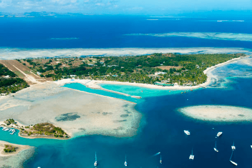
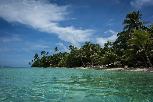
Levuka in the 1800’s was bustling with life. It is the only community in Fiji to have as much contact with the foreign world, and because of this an impromptu town was formed. The reasons behind Levuka’s settlement were quite easy. Levuka was strategically placed on Fiji’s map. When you do get the chance to look at the map of Fiji, you will notice that the island of Ovalau on which Levuka is located, is one of the few islands scattered in the middle of the Koro sea. Secondly, the Koro sea is encompassed by most of Fiji’s islands, with the Lauan islands to the east, Viti Levu’s seven provinces to the west, Kadavu’s southern provinces and Vanualevu’s three province’s to the north.
The island of Ovalau was strategically great as it was easier to pass through if a ship was coming from Tonga onward to the Bligh waters, to Bua, where Sandalwood trading was quite prosperous at the time. So, whalers, sandalwood traders and sailors found it much easier to stop through at Levuka for replenishment of supplies or a rest, with this settlement soon followed after.
The formation of a spontaneous town invited settlers, traders and even missionaries to Levuka. Levuka’s blooming population grew rapidly with the inclusion of European women. Soon, there was a need for a proper wharf, post office, schools, churches and even a lawful body to help control the ensuing chaos of lawlessness from lawlessness sailors, vagabonds and people with drunken escapades. The rugged, rough terrain that make-up the geographical landscape of Ovalau didn’t help in the expansion of Levuka. Perhaps the ideal of high-rise infrastructure was too difficult to comprehend at the time, as the cost of transporting building materials to the islands would be quite costly.
In 1877, three years after Fiji’s cession to the British empire the question of expanding infrastructure and layout caused a dilemma. Supposedly, a year later, in 1878 Lt. Col. F.E Pratt, then surveyor general, proposed the idea of a move of township to Suva in the province of Rewa, located on the south eastern part of Viti Levu. Yet, Pratt’s proposition wasn’t put in use until 1881, when the move became official. The move to Suva changed a lot, but Levuka, now with a lesser load, still stood to be the administrative centre for the Lomaiviti provincial council and the eastern division.
Suva

Reasons vary for why Suva was chosen to be the capital, but according to the Suva City Council website, the Polynesian Company had set up a township on the head of the bay between Tamavua river and Korovou. Like the British East India company, the company invested in commerce and agriculture and had just started buying land around the bay area. Between 1878 and 1881 negotiations were made between the company and the government, its topic was the purchase of the lands on Suva bay. So, in 1881 Suva, now officially a township, was responsible for all the British-Fijian administration and anything that dealt with the function of the young colony, Fiji.
The topography of Suva, similar to Levuka, had rugged and rough terrain, but what made it more advantageous was the more generous land space that Viti Levu had. The symbolic move to the young colony’s major start was the construction of the Queens Wharf in 1881, a tribute to the British monarch at the time, Queen Victoria.
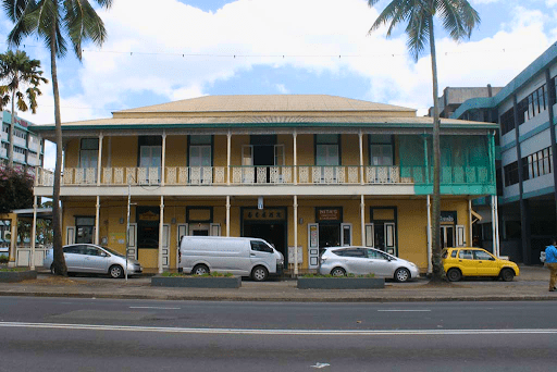
Today, Suva is a young, budding nation trying its best to shed most of its colonial history. Although, when moving around the capital, one cannot help but notice the remnants of the past, with some colonial buildings still erect and semi-developed buildings done in the name of growth. In 2022, the Suva area now perched on the entire peninsula has the capital city on its head and its suburbs with its industrial sites located further inland. The capital city now consists of few high-rise buildings, with most of its shorelines reclaimed and moved outward for a flatter topography.
What used to be the Queen’s wharf is now Pier street and one can measure the distance from there to the shoreline, which is about 200 metres or around 400 metres if you’re calculating from the same line of buildings vertically and outward to sea, to over the area of the King’s wharf, a replacement of its former counterpart. Looking at Suva instantly, one can easily overlook the remains of Fiji’s early colonial history. But if one is interested in searching up Suva’s colonial past without much effort and research, then you can just look at the top of most buildings in the areas of old Suva.
Nowadays, all primary focus is centred in Suva, and due to development, rapid urbanisation and population increase. The area keeps expanding inward towards Naitasiri highlands and Tailevu. In fact, the areas between Suva and Nausori town are now so densely populated that a visitor would not know where Suva officially ends. Simultaneously, Levuka has remained the same with hardly any development, which can be attributed to Levuka being a UNESCO world heritage site. Now a historical port town, Levuka preserves buildings like churches, government buildings, historical landmarks, traders stores and buildings. Levuka has such a rich history that it has been a keen subject among both local and international tourists.